

Topography
Digital Terrain Modeling(DTM)
Contour Mapping & Site Analysis
As-Built Topography Models

Creating intelligent digital terrain surfaces for design, planning, and construction analysis.
Generating accurate contour maps, slope analysis, and grading plans directly from real-world scans
Delivering as-built digital terrain models for renovations, expansions, and infrastructure projects.
16 APRIL 2024

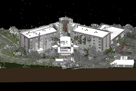
RIO De Janerio - School
Objective: Brazil school with all architecture and MEP fittings Scope: All Architecture and MEP fittings, Level of details: 350LOD Timeline: Estimated 25th December 2021 and 6th January 2022 Resources Required: Team and some families regarding this project
05 August 2025

Scan to 3D – ARCHITECTURE & MEPF
Scan to BIM is a cutting-edge process that transforms physical spaces into accurate 3D models, enhancing design and construction workflows for architecture MEPF (Mechanical, Electrical, Plumbing, and Fire protection) projects. By laser scanning technology, we capture precise measurements and details, allowing for seamless integration into Building Information Modeling (BIM).
10 October 2021
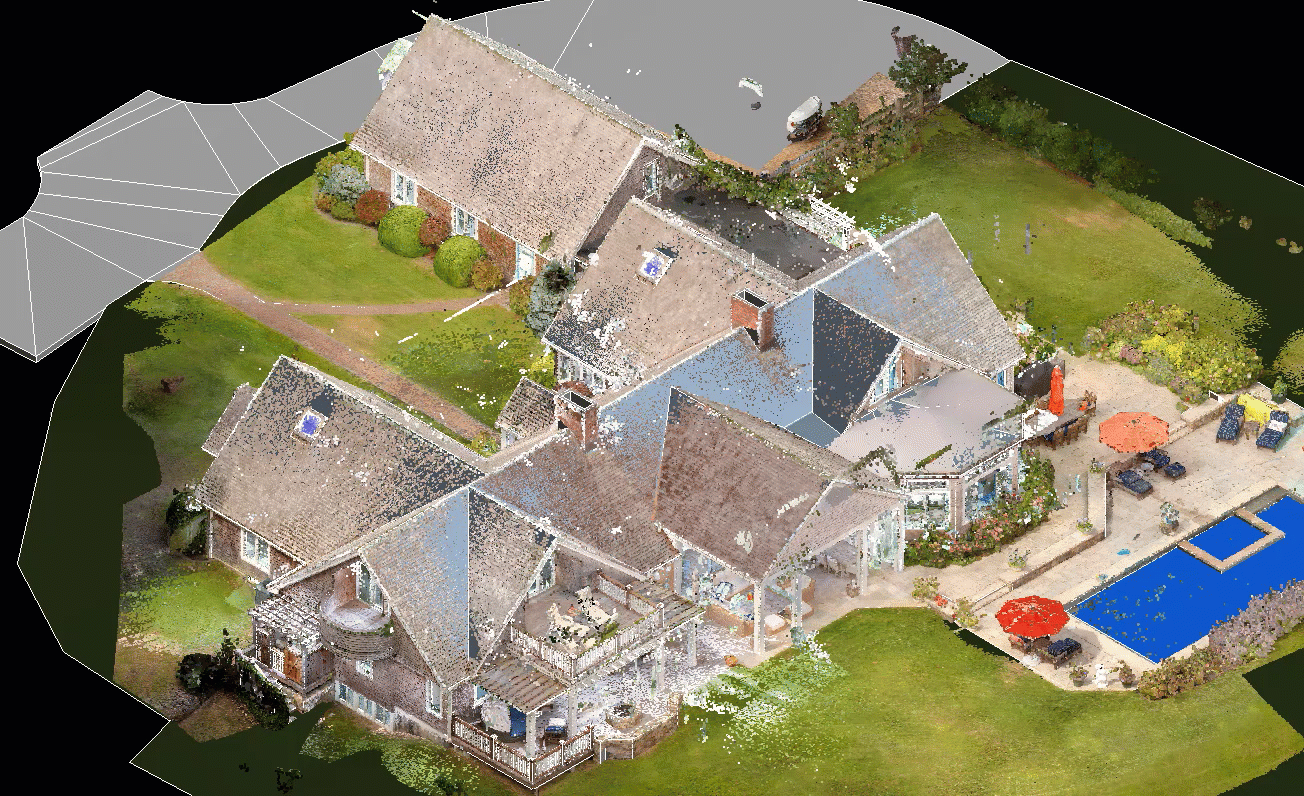
Brazil BIM Project - Hotel Architecture
We provide complete Scan-to-BIM services for hotels, including 3D laser scanning, point cloud processing, and accurate BIM modeling in Revit. Our team develops detailed Architectural, Structural, and MEP models at the required Level of Detail (LOD 300/350/400), ensuring precise as-built documentation of the property. The deliverables include Revit models, IFC files, and 2D drawings if needed, enabling seamless renovation, facility management, and future design work. This service guarantees accuracy, efficiency, and reduced project risks for your hotel project.
02 August 2020

SCAN To MEPF
Hello Everyone,
Things were so easy when we use Revit MEP. In this industrial area we used piping, ducting, piping accessories, ducting accessories, boxes, and blocks. So get your quotations from us based on :-
𝗠𝗲𝗰𝗵𝗮𝗻𝗶𝗰𝗮𝗹 𝗱𝘂𝗰𝘁𝗶𝗻𝗴, 𝗲𝗹𝗲𝗰𝘁𝗿𝗶𝗰𝗮𝗹 𝗰𝗮𝗯𝗹𝗲 𝘁𝗿𝗮𝘆𝘀, 𝗽𝗹𝘂𝗺𝗯𝗶𝗻𝗴 𝗮𝗻𝗱 𝗳𝗶𝗿𝗲 𝗳𝗶𝗴𝗵𝘁𝗶𝗻𝗴 𝗽𝗶𝗽𝗲𝘀 .
Application :- 𝗥𝗲𝘃𝗶𝘁, 𝗔𝘂𝘁������𝗰𝗮𝗱 𝗣𝗹𝗮𝗻𝘁𝟯𝗱
15 JUNE 2025

TOPOGRAPHY
We specialize in delivering topography-based projects which is around 10+ km area that provide highly accurate site data for design, planning, and construction. Using advanced surveying techniques such as drone mapping, LiDAR scanning, and total station surveys, we generate precise topographic maps and 3D surface models. These datasets capture natural landforms, contours, elevations, and existing site conditions, ensuring architects, engineers, and planners have a reliable foundation for project development. Our topography solutions help minimize design errors, optimize land use, and support smooth execution from concept to construction.
05 January 2020

Structure Project
We offer comprehensive structure-based project solutions that focus on accurate documentation and modeling of building structures. Our expertise includes detailed capture of structural elements such as columns, beams, slabs, foundations, and load-bearing walls using advanced surveying and BIM technologies. By creating precise 3D models and structural drawings, we provide a reliable foundation for analysis, renovation, retrofitting, or new construction. This approach ensures structural integrity, minimizes risks, and supports engineers, architects, and contractors in making informed decisions throughout the project lifecycle.
10 April 2020

Tower based project
We deliver specialized Scan-to-BIM services for tower projects, which are about 150+ projects we did capturing every detail of high-rise structures with advanced laser scanning and drone-based surveying. The collected point cloud data is processed into accurate 3D BIM models in Revit, covering Architectural, Structural, and MEP components at the required LOD (300/350/400). This ensures precise as-built documentation of the tower, enabling seamless renovation, facility management, and future expansion. Our tower-based Scan-to-BIM solutions reduce project risks, save time, and provide a reliable digital foundation for decision-making across all stages of the building lifecycle.
25 February 2023

BRIDGES
We provide specialized Scan-to-BIM solutions for bridge projects, delivering accurate as-built models that capture every structural detail. Using advanced 3D laser scanning and drone photogrammetry, we generate precise point cloud data of the bridge, which is then converted into a detailed BIM model in Revit or other platforms. The model includes structural elements such as piers, decks, abutments, girders, and reinforcement details, developed to the required Level of Detail (LOD 300/350/400). This process ensures reliable documentation, supports maintenance and rehabilitation planning, and enhances coordination for future upgrades, strengthening the overall lifecycle management of the bridge.